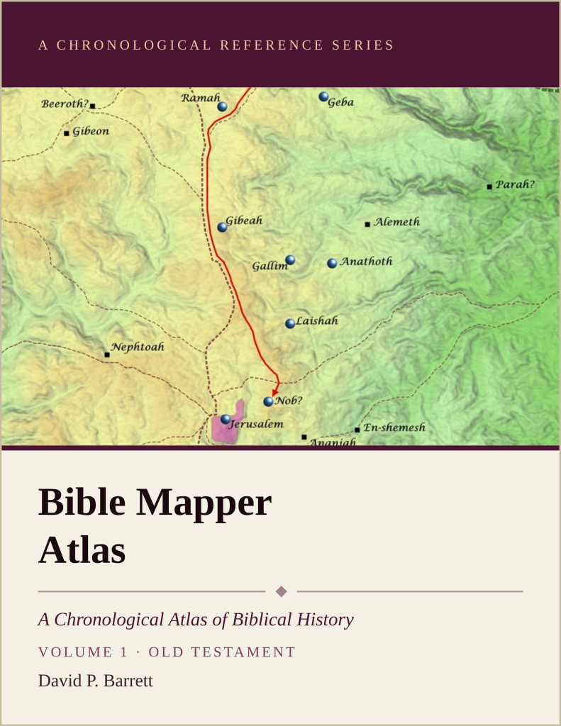
We are very excited to announce the publication of a full-color, print version of Bible Mapper Atlas, Volume 1 (Old Testament)! This first volume (344 pages) contains nearly all the online maps and articles related to the Old Testament, along with over 90 quality photographs of biblical locations and an extensive timeline that also includes all the maps. Price: $41.00, plus shipping and sales tax. Click here to order. Volume 2 (New Testament) is also coming soon!
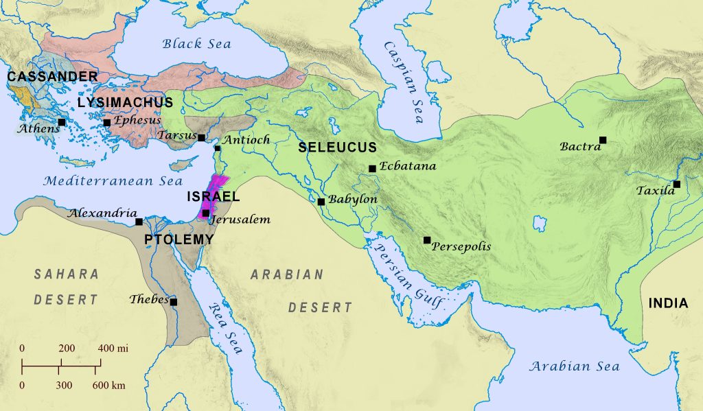
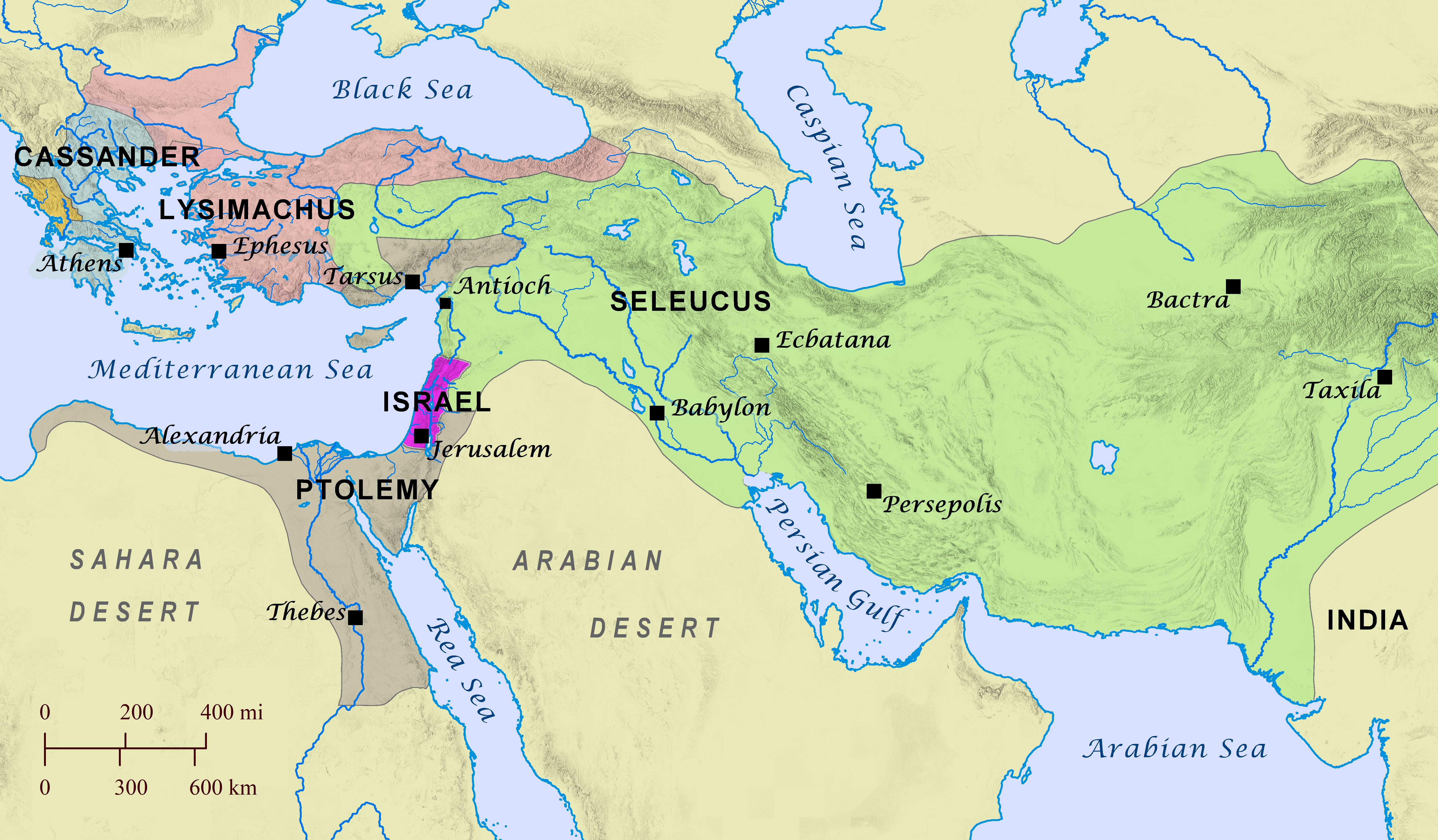
After Alexander the Great died in 323 B.C., at least seven different early successors (Greek Diodachi) fought to gain control over various parts of his empire. The largest and most powerful domains were established by the Ptolemaic rulers, who controlled Egypt, Cyprus, and the Tarsus region, and the Seleucid rulers, who controlled most of Alexander’s former empire in Asia. The boundaries of each ruler’s domain changed frequently, and initially the land of Israel came under the rule of the Ptolemies, but the Seleucid rulers repeatedly fought to seize it from them. Several chapters of the book of Daniel likely allude to events and struggles surrounding these tumultuous times.
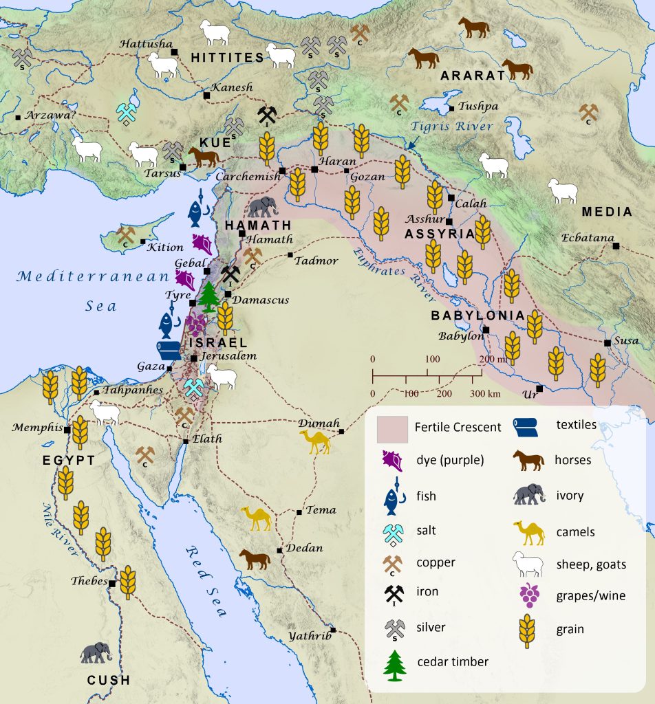
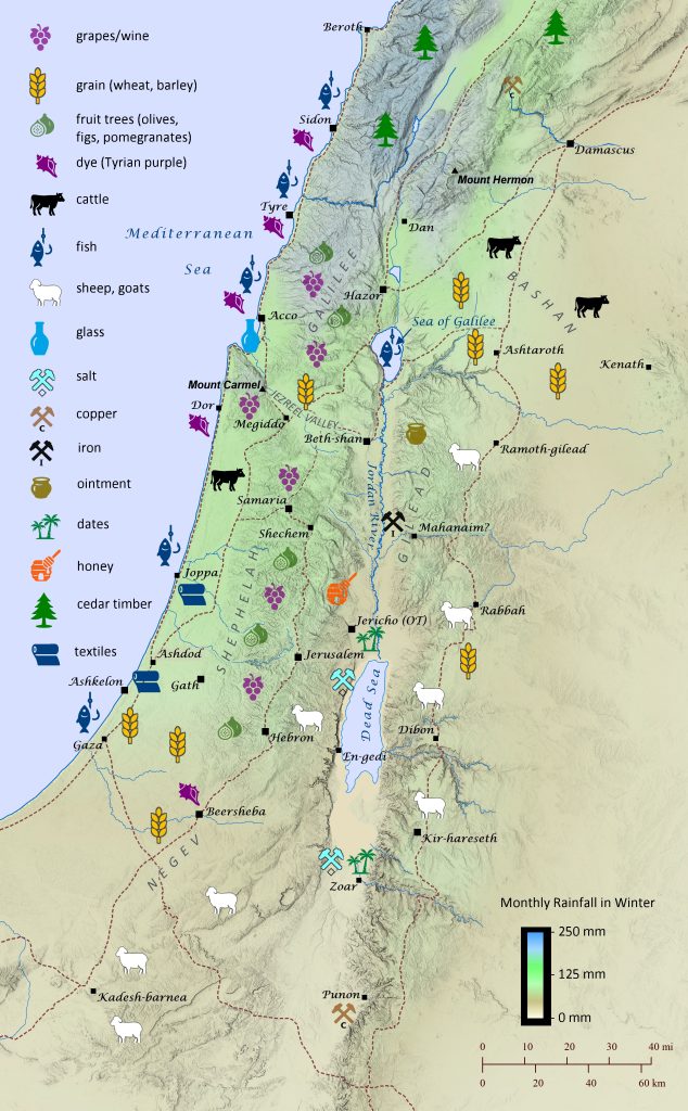
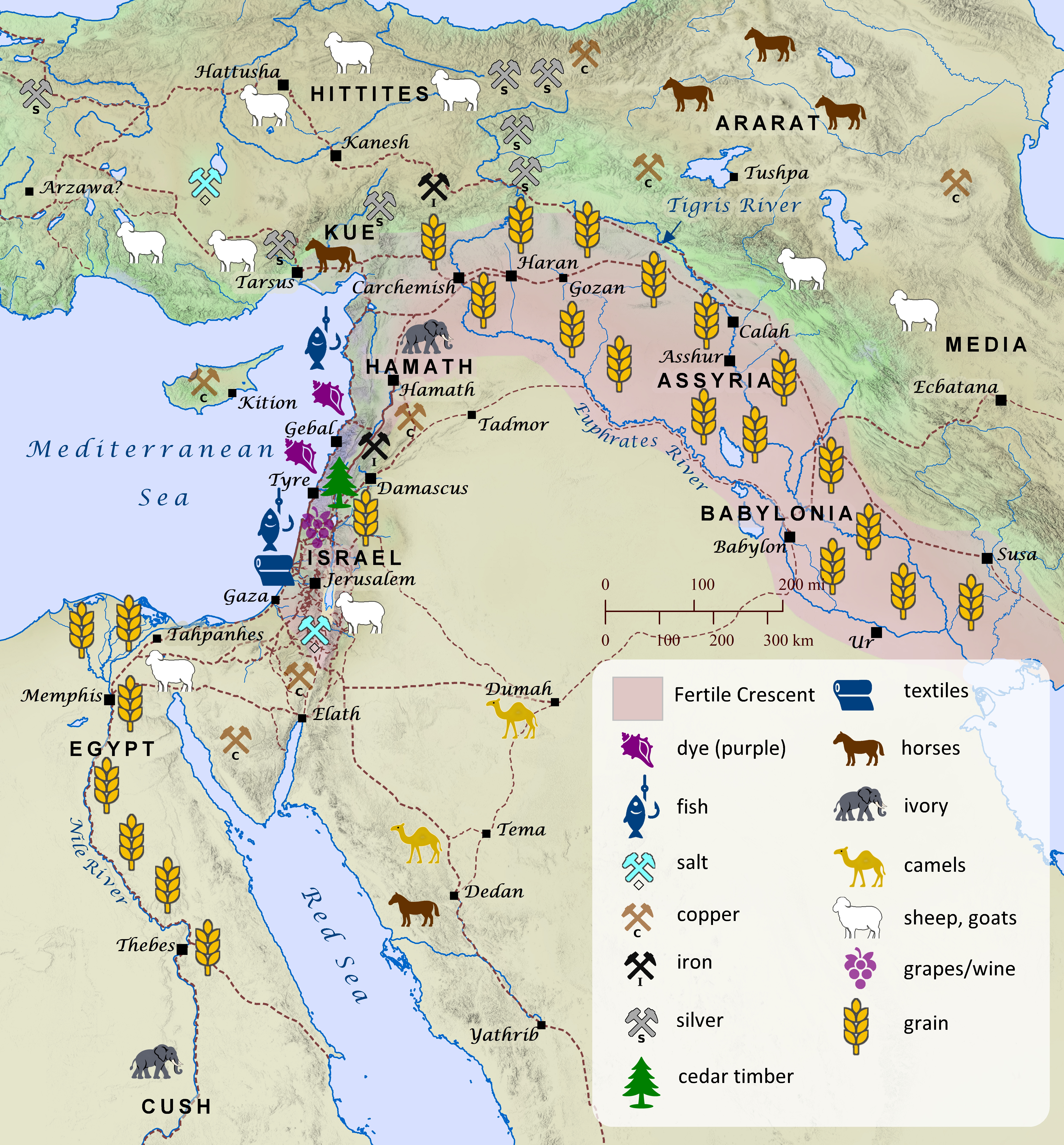
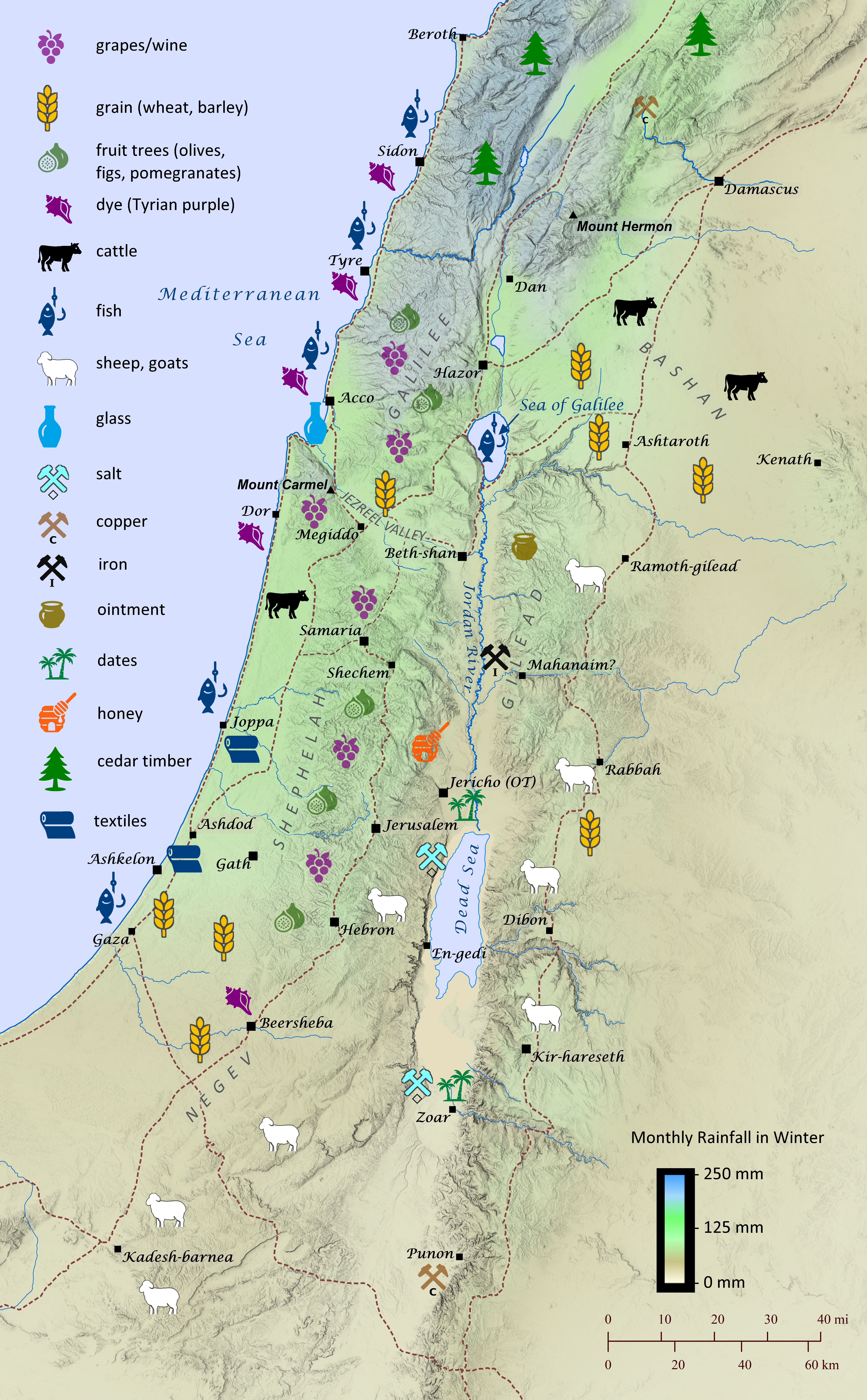
The economy of the ancient Near East, including the land of Israel, ranged from wheat farming and sheep herding to textile production and mineral mining. The land of Israel, though relatively small compared to the great civilizations of Egypt, the Hittites, and Mesopotamia, was particularly diverse in its many industries. This stemmed partially from its rapidly changing elevation and rainfall. Though many of the resources produced were for local consumption, it is clear from archaeology and the earliest stories of Scripture that international trade also played an important role throughout biblical history. The book of Genesis recounts that the patriarch Joseph was sold to Ishmaelite traders traveling from Gilead to Egypt with a load of balm and aromatic resin (Genesis 37:18-36; see “Joseph Is Sold into Slavery” map). Later Joseph rose to power in Egypt, and his own brothers repeatedly traveled from Canaan to Egypt to buy grain during a great famine (Genesis 41-42). During the reign of Saul, the Philistines made strategic use of their exclusive knowledge of iron blacksmithing by restricting any blacksmiths to ply their trade among the Israelites, because they feared they might produce weapons for them (1 Samuel 13:19–22). King Solomon appointed administrative governors to oversee the monthly collection of provisions for the royal court (1 Kings; see “Solomon’s Administrative Districts” map), and he made extensive international trade agreements, buying cedar and cypress timber from the king of Tyre to build the temple and paying him in wheat and olive oil (1 Kings 5:1-12; 2 Chronicles 2). Solomon also engaged in international arms dealing by importing horses from Kue (likely Cilicia) and chariots from Egypt and selling them to the kings of the Hittites and Arameans (1 Kings 10:28–29). His merchant ships traveled as far as Tarshish (likely modern Sardinia or Spain) and Ophir (likely near the southern end of the Red Sea) and returned every three years with precious and exotic goods (1 Kings 10; 2 Chronicles 8-9). His wisdom and riches gained him such international fame that the queen of Sheba in modern day Yemen traveled a thousand miles (1600 km) to visit him (1 Kings 10:1–13; see “Solomon’s International Presence” map). No doubt her intent was also to ensure that the trade routes from Sheba to the Mediterranean ports in southwestern Israel remained unobstructed so that the sale of aromatic resin and precious stones could continue. The Phoenicians of Sidon and Tyre likewise traded extensively throughout the entire Mediterranean world, establishing colonies in places as far away as Tunisia and Spain. During the time of the Judahite exile to Babylon, however, Ezekiel prophesied that the great wealth that the city of Tyre had gained from its worldwide economic trade would one day be swept away (Ezekiel 27; see “Tyre’s International Trade” map). By the time the Romans ruled the land of Israel, the historian Josephus and others note that the olive oil of Galilee had become famous throughout the world for its quality (The Jewish War, Book 2, Chapter 21). Likewise, glass made from the sands just south of Ptolemais (ancient Acco) is mentioned by both Tacitus (The Histories, 5.7) and Pliny the Elder (Natural History, 5.19; see “Poster Map of the Tribe of Zebulun and Its Surroundings, circa 1200 B.C.” map). By this time the Romans had even established trade connections with the land of China by means of the Silk Road (see “Lands beyond Persia” map).
The land immediately east of the Jordan River and the northern basin of the Dead Sea, often referred to today as the Transjordan, was conquered by the Israelites as they were preparing to enter the Promised Land (Numbers 21:21-35; 32:1-42; Deuteronomy 2:24-37; Judges 11:19-22). Later, during the time of Saul, these tribes also captured territory from three Hagrite tribes further east in the wilderness. It is possible that the Hagrite tribe of Nodab mentioned in 1 Chronicles 5:19 is the same as the tribe of Kedemah mentioned in Genesis 21:1-21; 25:1-18 (see “Nomadic Range of Ishmael’s Descendants” map). See “Poster Map of the Tribes of Reuben, Gad, and Manasseh (East)” for a detailed map of the territory of these eastern Israelite tribes.
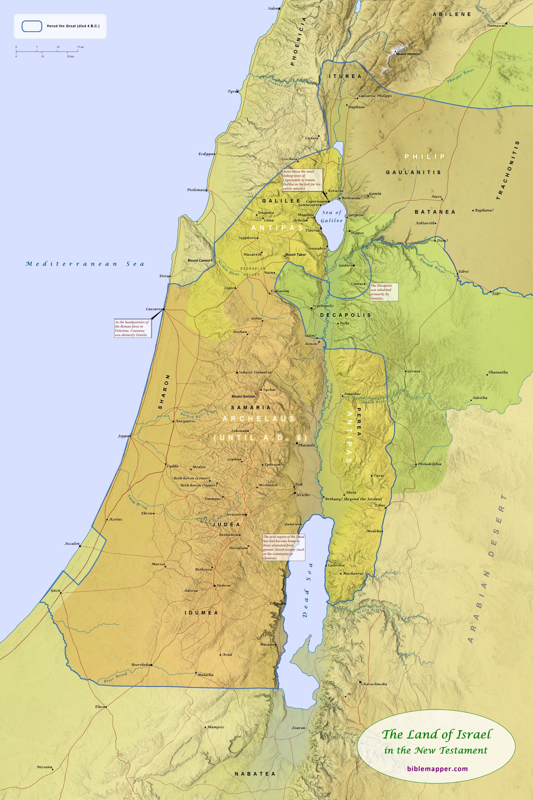
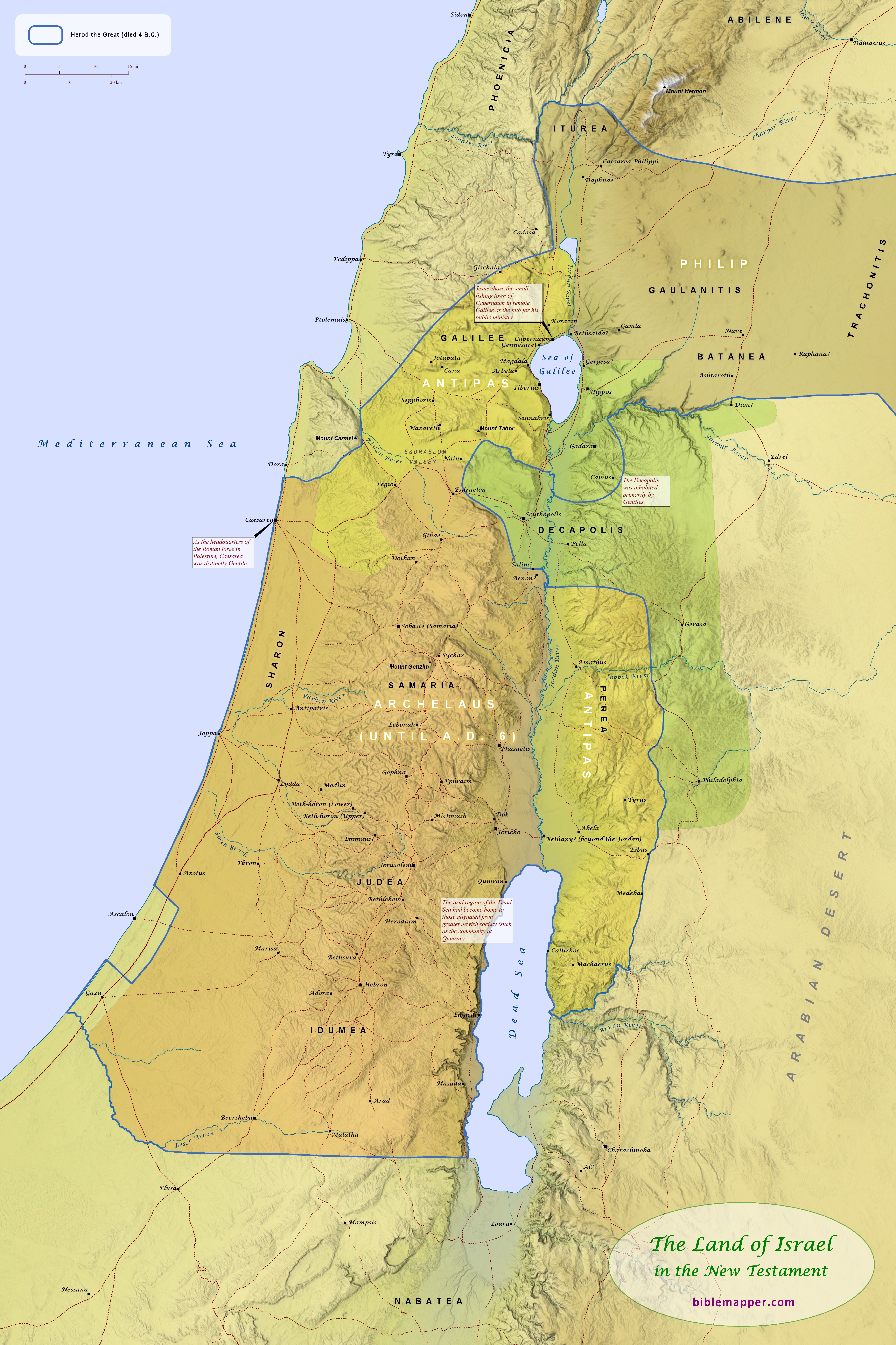
At the time of Jesus’ birth, the land of Israel (now called Palestine by the Romans) was ruled by the Romans, who had granted Herod the Great the title of “king” over the region (see “Palestine under Roman Rule” map). His domain included most of the land that once belonged to Israel. After his death, the Romans granted Herod’s wishes that his kingdom be divided among his sons Archelaus, Antipas, and Philip. The region of the Decapolis (“Ten Cities”) was never included in Herod’s kingdom and had a distinctly Gentile population and character. The cities of this region enjoyed semi-autonomous status under the Romans.
This map is designed to be printed at 24 in. x 36 in., but it may scale acceptably at larger or smaller sizes as well.